Best App for Santiago Buses in 2026

If you ride the Santiago bus network every day, having the right app on your phone makes the difference between arriving on time and being stuck at a bus stop with no idea what’s happening. In 2026 there are several options available — here’s a breakdown of which one fits each need.
What a good Transantiago app needs
Before comparing, let’s define what actually makes a transit app useful:
- Real-time bus location: the most important feature. Without it, you’re stuck with theoretical schedules that rarely hold.
- Interactive map: seeing the bus move on a map is far more intuitive than a list of times.
- Route list: ability to search and filter by route number.
- Direction indicator: knowing whether the bus is inbound or outbound.
- Free: public transport already costs money; the app shouldn’t add to that.
Top apps for the Transantiago in 2026
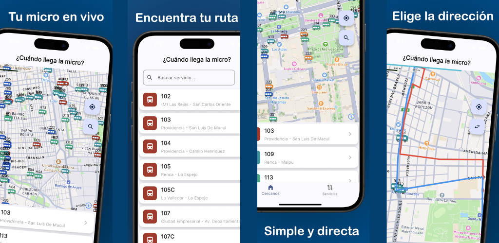
¿Cuándo llega la micro? — Real-time GPS tracker
¿Cuándo llega la micro? is an app built in Chile, designed specifically for the Red Metropolitana de Movilidad. Its focus is simple and direct: show on an interactive map where buses are right now.
Strengths:
- Real-time map with all active RED buses
- Clear identification by route number and color
- Shows bus direction (inbound/outbound)
- Full list of available routes
- 100% free, no intrusive ads
- Available for iPhone and Android
Best for: users who want to know exactly when their bus is coming before they leave home or while waiting at the stop.
Google Maps
Google Maps integrates Transantiago routes and lets you plan journeys combining bus, Metro and walking. It’s useful for finding how to get from point A to point B.
Key limitation: it does not show the real-time location of individual buses. It provides estimated arrival times based on historical schedules that don’t reflect current traffic conditions.
Best for: planning routes from scratch when you don’t know which routes to take.
Official Red Movilidad app
The official system app provides route and stop information, and lets you check estimated arrival times for a specific stop.
Limitation: the user experience has frequently been criticized for being slow and lacking an intuitive visual map.
Best for: spot-checks of official information.
RedBus (intercity bus ticketing app)
Important clarification: RedBus is primarily a platform for buying intercity bus tickets (Santiago–Valparaíso, Santiago–Concepción, etc.). It is NOT an urban Transantiago tracking app, despite what the name might suggest.
Best for: buying long-distance bus tickets.
Quick comparison
| Feature | ¿Cuándo llega la micro? | Google Maps | Red Movilidad app |
|---|---|---|---|
| Real-time GPS per bus | Yes | No | Partial |
| Interactive map | Yes | Yes | No |
| Route planning | No | Yes | Yes |
| Free | Yes | Yes | Yes |
| iPhone and Android | Yes | Yes | Yes |
Which app should you use?
The recommendation is to combine two apps depending on the situation:
- Google Maps to plan your route when you’re not sure which routes to take
- ¿Cuándo llega la micro? to see in real time when the bus is coming once you know your route
This combination covers the two core needs of every Transantiago rider: knowing how to get there and knowing when the bus comes.
You might also like
What Time Does the Bus Come? Free Real-Time App for Santiago
Find out what time the bus comes in Santiago with a free app: real-time GPS position, Metro alerts, and notifications so you never miss your ride.
April 23, 2026
How to Know Where Your Bus Is Right Now – Free App for Santiago
Find out exactly where your bus is with a free app for Santiago: live GPS position on the map, route stops, and smooth real-time tracking.
April 23, 2026
Free App to See Buses in Real Time in Santiago
Discover the free app to see Santiago buses in real time: interactive map, smooth animated markers, and all RED routes on your screen.
April 23, 2026