Getting to Work and the Airport by Bus in Santiago

Getting to work on time — or catching a flight — often comes down to knowing exactly when your bus is coming. Transantiago (officially the Red Metropolitana de Movilidad) covers virtually the entire Santiago metropolitan area, but making the most of it takes some planning. Here’s how.
How to plan your commute on Transantiago
Step 1: Find the right route
Start by identifying which routes stop near your origin and get close to your destination. You can look them up on:
- Google Maps: integrates RED routes and plans door-to-door trips
- The official Red Movilidad app: shows routes and bus stops
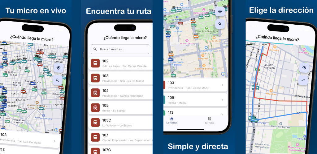
- ¿Cuándo llega la micro?: shows all active routes on the map with real-time bus positions
Step 2: Learn your route’s frequency
Transantiago doesn’t run on a fixed timetable like a train, but it does follow approximate frequency bands depending on the time of day:
| Time of day | Estimated frequency (trunk routes) |
|---|---|
| 6:00–9:00 (morning peak) | Every 3–8 minutes |
| 9:00–18:00 (off-peak) | Every 10–20 minutes |
| 18:00–21:00 (afternoon peak) | Every 5–10 minutes |
| 21:00–24:00 (late night) | Every 20–30 minutes or more |
Peripheral routes tend to have lower frequency. It’s always worth checking in real time.
Step 3: Use live GPS to leave at exactly the right moment
The key to not standing at the bus stop longer than needed is knowing when the next bus is coming before you leave home. Open ¿Cuándo llega la micro?, find your route on the map, and estimate how much time you have.
If the bus is 10 blocks away, leave now. If it just passed and the next one is far off, finish your coffee first.
Getting to the airport by bus
Arturo Merino Benítez International Airport is in the municipality of Pudahuel, west of Santiago. There are bus-based alternatives to taxis and private transfers.
Option 1: Centropuerto bus
The Centropuerto service connects the airport directly to central Santiago (Pajaritos and Los Héroes stations). It’s not part of the Transantiago RED network, but it’s the most direct bus option to the airport. It runs from early morning to midnight with fixed stops.
Option 2: Metro + RED bus combination
Take Metro Line 5 to Pudahuel station, then catch a RED bus from there to the airport. This combination takes longer but can be cheaper.
What to keep in mind when heading to the airport
- Build in buffer time: Transantiago’s variability means you should add at least 30–45 extra minutes to your travel estimate
- Check the bus before you leave: use ¿Cuándo llega la micro? to see the bus’s live position
- Check the day and time: on weekends and holidays, frequency drops significantly
Tips for frequent Transantiago riders
- Know 2 or 3 alternative routes for your regular trip. If one is running late, another might get you there just as well.
- Watch the direction: inbound vs. outbound matters. ¿Cuándo llega la micro? shows this clearly for every bus on the map.
- Avoid peak hours when you can: between 7:30–9:00 and 18:00–20:00, buses tend to run later and more crowded.
- Keep your BIP card topped up: you can’t board without balance. Reload at Metro stations or authorized points of sale.
The essential tool: real-time bus tracking
No trip plan is complete without up-to-date information. ¿Cuándo llega la micro? gives you that for free — whether you’re heading to work or catching a flight.
You might also like
Track Your Bus in Real Time – Santiago (RED / Transantiago)
See your bus in real time on the map in Santiago. Stop guessing at the bus stop and plan your trips on the Transantiago (RED) network with total precision.
March 5, 2026
What Time Does the Bus Come? Free Real-Time App for Santiago
Find out what time the bus comes in Santiago with a free app: real-time GPS position, Metro alerts, and notifications so you never miss your ride.
April 23, 2026
How to Know Where Your Bus Is Right Now – Free App for Santiago
Find out exactly where your bus is with a free app for Santiago: live GPS position on the map, route stops, and smooth real-time tracking.
April 23, 2026