Santiago Bus Routes by Number – Complete Guide

The Red Metropolitana de Movilidad (Santiago’s public bus network, commonly known as Transantiago) operates hundreds of routes identified by numeric and alphanumeric codes. If you’re looking for information on a specific route — the 201, 214, 301, 505 or any other — this guide explains how the system is organized and how to see your bus in real time.
How Santiago’s bus routes are organized
Routes are grouped in numeric series that follow a general geographic logic:
100 Series — Northeastern and central sectors
Routes connecting the northern, northeastern, and central areas of Santiago. Most searched:
- 104: northern sector route
- 106: northeastern sector connector
- 107: north-central sector route
- 109: major trunk route of the northern sector
- 110: northeastern route
- 111: north toward the center
- 118: northeastern sector route
200 Series — Eastern and central sectors
Routes covering eastern municipalities such as Las Condes, Providencia, Ñuñoa and central areas:
- 201: east-center trunk route, one of the most used in the city
- 201e: variant of the 201, serves eastern sectors
- 210: eastern sector route
- 214: connects the eastern sector with the center
- 225: eastern-southern sector route
300 Series — Southern and southeastern sectors
Routes connecting southern municipalities such as La Florida, Puente Alto, San Joaquín:
- 301: southern sector trunk route, high demand during rush hour
400 Series — Western and southern sectors
Routes covering western municipalities such as Pudahuel, Cerrillos, Maipú:
- 401: southwest sector route
- 405: western sector connector
- 430: west-south sector route
500 Series — Peripheral zones and Metrobus
Routes serving areas further from the center and connections with peripheral municipalities:
- 505: peripheral zone route
- 506: variant of the 500 series
Circular routes — C Series
- C01: circular route connecting sectors without going through the center
Special zones and sectors
Zones F and H
- Zone F: western Santiago, including Pudahuel, Lo Prado and Cerro Navia
- Zone H: southern and western peripheral sectors
Colina
The municipality of Colina, north of Santiago, is connected to the system via RED and Metrobus routes that reach the nearest northern Metro station (Vespucio Norte or Quilicura, depending on the route).
Padre Hurtado
The municipality of Padre Hurtado, west of Santiago on Route 68, has RED routes connecting it to the metropolitan area. Travel times are longer than in central municipalities.
Metrobus and highway express bus
The Metrobus is a complementary service to the RED that operates on high-speed corridors including the central highway and other expressways. It connects areas the Metro doesn’t reach, and operates on segregated lanes in some cases, providing greater speed and reliability.
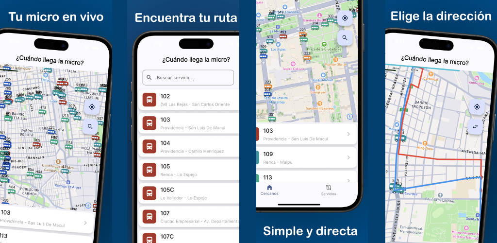
How to track any route in real time
Whatever route number you need, ¿Cuándo llega la micro? lets you:
- View all available routes in a complete list
- Select the route you need (e.g. 201, 301, 505)
- See the real-time location of the buses on that route on the map
- Know whether they are inbound or outbound
It’s the fastest way to answer the question: how long until my bus arrives?
Operators and BIP card
RED buses are operated by different companies under government contract. The operator doesn’t change the user experience from a GPS standpoint — all buses have real-time tracking regardless of who operates them.
To ride any Transantiago route you need balance on your BIP card (Santiago’s rechargeable transit card). You can reload it at Metro stations, authorized points of sale (pharmacies, supermarkets, kiosks), or via the official BIP app.
Find your bus with the app
Whether you ride the 201, 301, 505 or any other route, ¿Cuándo llega la micro? is the simplest way to track your bus in real time. Free, no sign-up, available for iPhone and Android.
You might also like
¿Cuándo llega la micro? Track Your Bus in Real Time
Official launch of '¿Cuándo llega la micro?', the new free app for Chile that lets you track and see your bus's location in real-time on the map.
October 5, 2025
What Time Does the Bus Come? Free Real-Time App for Santiago
Find out what time the bus comes in Santiago with a free app: real-time GPS position, Metro alerts, and notifications so you never miss your ride.
April 23, 2026
How to Know Where Your Bus Is Right Now – Free App for Santiago
Find out exactly where your bus is with a free app for Santiago: live GPS position on the map, route stops, and smooth real-time tracking.
April 23, 2026