Transantiago (RED): Complete Guide to Santiago's Bus Network

Transantiago, now officially known as the Red Metropolitana de Movilidad (or simply RED), is Santiago de Chile’s public bus system. With over three million trips per day, it’s one of the largest urban transit systems in Latin America.
Whether you’re a regular commuter or just arrived in Santiago, this guide covers everything you need to know: how the system works, how to find routes and stops, fares, and how to use technology to travel without the guesswork.
What is Transantiago (Red de buses)?
The system launched in 2007 as “Transantiago” and underwent a major restructuring between 2018 and 2022, when it was rebranded as the Red Metropolitana de Movilidad. It integrates:
- RED buses: the urban bus network covering the entire metropolitan area
- Metro de Santiago: the subway network, which operates in tandem with the buses
- Metrobus: buses connecting areas of the metropolitan region not served by the Metro
Payment is made with the BIP card (Santiago’s rechargeable transit card), which enables fare integration between bus and Metro within the same time window.
Transantiago routes: how they’re organized
The bus network is divided into routes identified by alphanumeric codes. For example:
- 201, 210, 214, 225: numbered routes serving the eastern and central sectors
- 301, 401, 405, 430: southern and western sector routes
- 505, 506: peripheral zone routes
- C01, C02: circular routes
Each route runs in two directions — inbound and outbound — which is important to note so you don’t board a bus going the wrong way.
Bus stops: how to identify them
Transantiago bus stops are marked with yellow signs listing the route numbers that stop there. Each stop has a unique code (for example, “PI1234”) that you can use to check arrival times.
Stop locations vary: some are at major intersections with high-frequency service, while in peripheral areas they may be more spread out.
Schedules and bus frequency
RED buses generally operate between 6:00 and 24:00, with variations by route and day of the week. Frequency depends on the time of day:
- Peak hours (7:00–9:00 and 18:00–20:00): more buses, shorter waits
- Off-peak hours: less frequent service
- Weekends and holidays: reduced frequency on most routes
A longstanding challenge of the system is irregularity: buses don’t always follow their theoretical schedules due to traffic. This is why knowing the real-time location of buses is far more useful than relying on a fixed timetable.
Transantiago fares
Fares are adjusted periodically. The standard adult fare is paid with the BIP card. Discounted rates exist for:
- Students (with valid student ID)
- Senior citizens (with SENAMA credential — Chile’s National Service for the Elderly)
- Young children (ride free up to a certain age)
Fare integration allows a transfer between bus and Metro — or between two buses — within the same time window without paying a full additional fare.
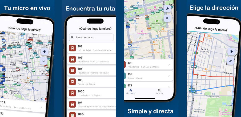
How to track your bus in real time
This is the question Transantiago users ask most often. The system has GPS on all its buses, and that data is publicly available.
¿Cuándo llega la micro? is a free app for iPhone and Android that shows live bus positions on an interactive map. With it you can:
- See exactly where your bus is on the map, in real time
- Identify routes by number and color
- Know whether the bus is inbound or outbound
- Plan precisely when to leave your home
Frequently asked questions about Transantiago
Where can I see the Transantiago map? The official route map is on the Red Movilidad website. For live bus positions, the ¿Cuándo llega la micro? app is the most practical tool.
How do I plan a trip on Transantiago? You can use Google Maps (which integrates the RED network) or the Red Movilidad app to plan routes. To know exactly when your bus will arrive once you’re at the stop, use ¿Cuándo llega la micro?.
Does Transantiago go to the airport? Yes. There are routes connecting different parts of Santiago to Arturo Merino Benítez International Airport. Check available routes in the app.
How do I reload my BIP card? You can reload at Metro stations, authorized points of sale (pharmacies, supermarkets), or through the official BIP app.
Conclusion
Transantiago / Red de buses is a complex but essential system for getting around Santiago. Knowing its structure, stops, and routes saves you time and stress. And to avoid relying on unreliable timetables, download ¿Cuándo llega la micro? and travel with real-time information in your pocket.
You might also like
What Time Does the Bus Come? Free Real-Time App for Santiago
Find out what time the bus comes in Santiago with a free app: real-time GPS position, Metro alerts, and notifications so you never miss your ride.
April 23, 2026
How to Know Where Your Bus Is Right Now – Free App for Santiago
Find out exactly where your bus is with a free app for Santiago: live GPS position on the map, route stops, and smooth real-time tracking.
April 23, 2026
Free App to See Buses in Real Time in Santiago
Discover the free app to see Santiago buses in real time: interactive map, smooth animated markers, and all RED routes on your screen.
April 23, 2026