Free App to See Buses in Real Time in Santiago

Tired of standing at the bus stop with no idea whether your bus is around the corner or still ten blocks away? There’s a better way: see every bus on a live map, right from your phone. And it’s completely free.
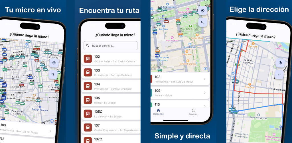
¿Cuándo llega la micro? is the free app for iPhone and Android that displays the GPS position of every RED Metropolitan Network bus on an interactive map, updated second by second.
How does the RED bus GPS system work?
Every bus on Santiago’s Transantiago network (now called RED) is equipped with GPS. That data is public, and ¿Cuándo llega la micro? turns it into an easy-to-read map: each bus appears as a marker showing its route number and line color, moving in real time through Santiago’s streets.
No stop codes, no schedules needed. Just open the app and look.
What you can see in real time
Markers that move smoothly
With version 2.4.0, bus markers no longer “jump” from one position to the next — they now slide smoothly across the map, just as the bus moves physically down the street. This makes it much easier to visually follow your route and estimate how long it will take to arrive.
All buses in the area also load together rather than appearing one by one, giving you the full picture at once.
Colors and data always up to date
Line colors update automatically whenever official information changes. If a route changes its color or number, the app reflects it instantly — no action needed on your part.
Route stops on the map
When you follow a specific route, version 2.4.0 now shows the stops for that route marked on the map. You can see at a glance which stops the bus will pass before reaching yours, and how many blocks you’d need to walk to the nearest stop.
Better performance since version 2.2.0
Version 2.2.0 improved the overall speed and stability of the app. Viewing buses in real time, searching routes, and exploring the map all became smoother, with interface adjustments that work well on every screen size from small iPhones to large Android devices.
Does it work for every Transantiago route?
Yes. The app uses official GPS data from the Red Metropolitana de Movilidad, covering all active RED routes in the Greater Santiago area. Search any route by number from the built-in list.
| What you want to know | What the app shows |
|---|---|
| Where is the bus right now? | Live marker on the map |
| Route number and color | Yes, auto-updated |
| Direction (inbound / outbound) | Yes |
| Route stops | Yes (when following a route, v2.4.0) |
| Metro alerts | Yes, faster since v2.4.0 |
Tips to get the most out of the real-time map
- Enable location access: Allow the app to use your GPS so the map centres automatically on your position and shows you the nearest buses immediately.
- Check before you leave home: Open the map two or three minutes before heading to the stop so you know whether to hurry or whether you have time to spare.
- Track more than one route: If multiple bus routes work for you, watch which one arrives first and choose accordingly — the app shows all active buses simultaneously.
- Combine the map with Metro alerts: Since version 2.4.0, Metro service alerts appear in the app too. If your trip combines Metro and bus, you can plan both legs from the same screen.
- Try it at different times of day: Bus density on the map varies significantly by hour. Checking at peak vs. off-peak times gives you a real sense of how frequently your route runs.
Frequently asked questions
Does the app work across all of Greater Santiago? Yes. The GPS data covers all active RED routes in the Santiago metropolitan area, including outlying districts such as Puente Alto, Maipú, La Florida, San Bernardo, and Lo Barnechea. If your route is operating in the RED network, it appears on the map.
Do I need to create an account or sign up? No. The app requires no registration or account creation. Download it, open it, and buses appear on the map immediately — no extra steps.
How much mobile data does it use? Consumption is moderate. The app updates positions in real time and is optimised to use as little bandwidth as possible. It works fine on 4G, LTE, or WiFi. In areas with weak signal, markers may take a moment longer to refresh.
Does it work at night and on weekends? Yes, whenever RED buses are operating. During low-frequency periods — late nights, public holidays — you’ll see fewer buses on the map. That’s useful information too: if no markers are visible, service is reduced and you may want to consider other transport options.
Is the data official or from a third party? The data comes directly from the GPS units installed on Red Metropolitana de Movilidad buses — the same source used by Santiago’s official system. The app shows the real position of each bus, not estimates or third-party data.
Download the app and see your buses in real time
No more guessing. With ¿Cuándo llega la micro? you have the full bus map in your pocket — free, for iPhone and Android.
You might also like
What Time Does the Bus Come? Free Real-Time App for Santiago
Find out what time the bus comes in Santiago with a free app: real-time GPS position, Metro alerts, and notifications so you never miss your ride.
April 23, 2026
How to Know Where Your Bus Is Right Now – Free App for Santiago
Find out exactly where your bus is with a free app for Santiago: live GPS position on the map, route stops, and smooth real-time tracking.
April 23, 2026
Santiago Bus Routes by Number – Complete Guide
Guide to Santiago's bus routes by number. Find your 201, 214, 225, 301, 401, 505 and more with a real-time map of the Transantiago (RED) network.
March 5, 2026