How to Know Where Your Bus Is Right Now – Free App for Santiago

You’re at the bus stop and the question is always the same: where is my bus right now? Has it already turned the corner, or is it still a few blocks away? The exact answer is in your pocket — with a free app for iPhone and Android.
Why is it so hard to know where your bus is without an app?
RED buses don’t follow a fixed timetable: traffic, traffic lights, and passenger boarding constantly affect their position. Standing at the stop and looking down the street tells you nothing precise. What you need is the real GPS location of the bus, right now.
How to see where your bus is with the app
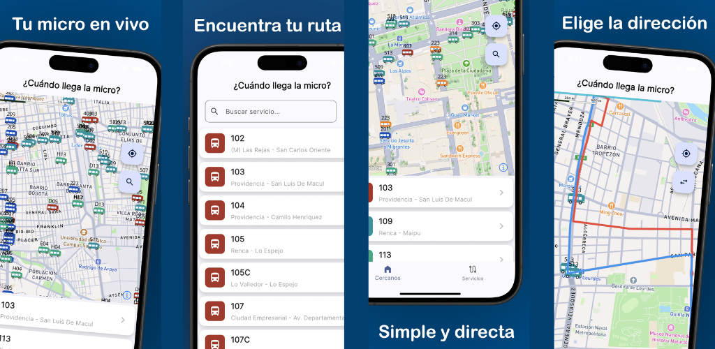
¿Cuándo llega la micro? is the free app that shows the exact position of every RED bus on an interactive map, updated in real time. Here’s how to use it:
1. Open the map
When you launch the app, you’ll see the map centred on your location with all active buses in the area shown as markers. Each marker displays the route number and line colour.
2. Select your route
Tap your route name in the list or directly on a marker in the map. The app filters and highlights only the buses for that route so you don’t get confused by others.
3. See the route’s stops on the map
Since version 2.4.0, when you follow a route the stops for that route appear marked on the map. You can see exactly which stops the bus will pass before reaching yours, and estimate how many stops are left.
4. Follow the bus as it moves
Bus markers slide smoothly across the map (a version 2.4.0 improvement), making it much easier to visually track the bus block by block.
Fixes that improve the location experience
Version 2.4.0 also fixed an issue where the map camera didn’t centre on your location when launching the app, and another where old buses didn’t disappear from the map when switching to a different area. The map now always shows only the buses relevant to your zone.
Version 2.2.0 improved map loading speed and overall stability, so bus information appears more reliably at all times.
Does it work for any bus in Santiago?
Yes. The app covers all active RED routes in the Santiago metropolitan area using official GPS data from the Red Metropolitana de Movilidad. If your route is in the RED network, you can see it on the map.
| What you want to know | What the app shows |
|---|---|
| Where is the bus right now? | Live marker on the map |
| Which stops will it pass? | Route stops on the map (v2.4.0) |
| Inbound or outbound? | Direction shown on the marker |
| Are there more buses on this route? | All route buses visible simultaneously |
Tips for always knowing where your bus is
- Select your route before leaving: Open the app while still at home or work. Arrive at the stop just as the bus is about to pass — no unnecessary waiting.
- Look at all buses on the route, not just the first: During rush hour there may be several buses on the same route at different distances. The one that looks furthest away might actually be moving faster with fewer stops ahead.
- Use the stop markers to pick a better stop: With the v2.4.0 stop display, you can check whether walking one block to an earlier stop guarantees you a seat.
- Check the bus direction: Each marker shows whether the bus is going inbound or outbound. This avoids confusion on routes that pass in both directions at the same stop.
Frequently asked questions
What if I see no buses on the map? This can happen for two reasons: the route may be operating in a low-frequency period (very early morning, late night, or holidays), or you may be searching for a route that doesn’t serve your area. Verify you’ve selected the correct route and that the map is centred on your actual location.
Can I see how many buses are coming on my route? Yes. When you select a route, the map simultaneously shows all active buses on that line — both those heading towards you and those going in the opposite direction.
Is the bus position updated in real time or is there a delay? Updates are nearly instantaneous. Buses transmit their GPS position continuously and the app reflects it within seconds. With version 2.4.0’s smooth marker movement, you can see the bus actually moving without interruptions.
Does the app work without an internet connection? The app requires an internet connection to show real-time positions. Without connectivity, the map cannot update. Mobile data or WiFi is recommended for a complete experience.
Can I save my favourite routes? The development team continuously adds new features. Check for app updates in the App Store or Google Play to discover the latest improvements available.
Download the app and stop wondering
The question “where is my bus?” has a precise answer. Download ¿Cuándo llega la micro? for free on iPhone or Android and see your bus’s position in real time.
You might also like
What Time Does the Bus Come? Free Real-Time App for Santiago
Find out what time the bus comes in Santiago with a free app: real-time GPS position, Metro alerts, and notifications so you never miss your ride.
April 23, 2026
Free App to See Buses in Real Time in Santiago
Discover the free app to see Santiago buses in real time: interactive map, smooth animated markers, and all RED routes on your screen.
April 23, 2026
Santiago Bus Routes by Number – Complete Guide
Guide to Santiago's bus routes by number. Find your 201, 214, 225, 301, 401, 505 and more with a real-time map of the Transantiago (RED) network.
March 5, 2026