What Time Does the Bus Come? Free Real-Time App for Santiago

You need to be somewhere at a specific time. What time does the bus come? How long until it arrives? Fixed timetables aren’t enough — Santiago’s traffic means any printed schedule is just an estimate. What you need is the real position of the bus right now.
Why doesn’t the bus have a fixed timetable?
Unlike the Metro, RED buses run on roads with variable traffic. An accident, a closed street, or simply rush hour can delay or speed up any route by several minutes. The approximate schedules you find online are averages, not guarantees.
The only reliable way to know when the bus will pass is to check where the bus is at this very moment and calculate how long it will take to reach your stop.
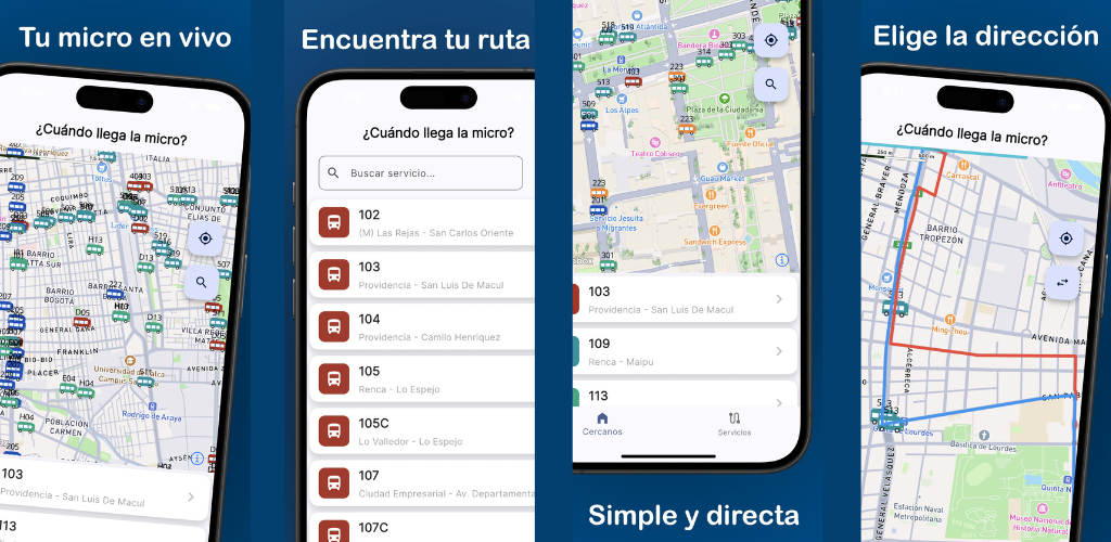
How to use the app to know what time the bus comes
¿Cuándo llega la micro? is a free app for iPhone and Android that shows the GPS position of every RED bus in real time. Here’s how to use it to plan your departure:
- Open the app and you’ll see the map with active buses near your location
- Find your route in the list to filter only the buses you care about
- Count how many blocks the nearest bus is from your stop
- Decide whether to leave now, wait a few minutes, or take another option
Since version 2.4.0, bus markers slide smoothly across the map, making it far more accurate to estimate arrival time by visually tracking the bus’s real movement.
Alerts and notifications: always in the loop
Version 2.4.0 added a dedicated notifications section inside the app and made Metro alerts arrive faster. You’ll know about service interruptions or route changes before reaching the stop, giving you time to adjust your trip.
If you combine the Metro with a bus connection, this improvement is especially useful: faster alerts mean you can reroute before it’s too late.
How long does the bus usually take? Reference frequency table
While there’s no fixed schedule, these are the typical ranges by route type:
| Situation | Estimated wait |
|---|---|
| Rush hour, trunk route | 3 to 8 minutes |
| Off-peak weekday | 10 to 20 minutes |
| Weekend or holiday | 20 to 40 minutes |
| Peripheral route | Variable, can exceed 30 min |
These are guidelines. The app gives you the exact real-time answer, which is always more accurate than any table.
Better reliability since version 2.2.0
Version 2.2.0 improved overall app speed and stability, with fixes that make information load more reliably. The interface adapts better to different screen sizes, from the smallest iPhone to large Android devices.
Tips to never miss your bus again
- Check the map 5 minutes before leaving: Seeing the bus position in advance lets you time your departure precisely. If the bus is ten blocks away, you have time. If it’s two blocks away, it’s time to move.
- Enable app notifications: The notifications section added in version 2.4.0 lets you receive service alerts affecting your route or your Metro + bus combination.
- Watch the bus direction on the map: Some routes have buses going in both directions past the same stop. Always check the direction arrow on each marker to avoid boarding one going the wrong way.
- Compare with the next bus: If the first bus is very far away, check whether the next bus on the same route is close enough to be worth waiting for instead.
- Use the app alongside the Metro: Metro alerts now arrive faster (version 2.4.0), so if a Metro disruption affects your connection, you can instantly see alternative bus positions on the same screen.
Frequently asked questions
How do I know exactly how many minutes until the bus arrives? The app shows real-time GPS position on the map. It doesn’t display an exact minute countdown, but by watching the distance between the bus and your stop and how quickly the marker advances, you can estimate arrival time quite accurately.
Can I get an alert when the bus is nearby? Version 2.4.0 introduced a notifications section in the app. Keep the app updated to access the latest alert features available.
Does the app show estimated route frequency? The app focuses on showing real-time GPS positions of active buses. You can observe the gap between buses of the same route on the map to get a sense of the current frequency.
What should I do if the bus appears very delayed? If the map shows the nearest bus is still far away, use that time to check whether alternative routes nearby are closer, or whether a Metro + bus combination might work better for that particular moment.
Does this app work for Santiago’s Metro too? The app is focused on RED buses, but since version 2.4.0 it includes faster Metro alerts so you can coordinate combined trips from a single place.
Download the app and plan your trip with precision
There’s no fixed timetable for when the bus passes. But there is a free app that shows exactly where your bus is right now. Download ¿Cuándo llega la micro? and stop guessing when the next bus will arrive in Santiago.
You might also like
How to Know Where Your Bus Is Right Now – Free App for Santiago
Find out exactly where your bus is with a free app for Santiago: live GPS position on the map, route stops, and smooth real-time tracking.
April 23, 2026
Free App to See Buses in Real Time in Santiago
Discover the free app to see Santiago buses in real time: interactive map, smooth animated markers, and all RED routes on your screen.
April 23, 2026
Santiago Bus Routes by Number – Complete Guide
Guide to Santiago's bus routes by number. Find your 201, 214, 225, 301, 401, 505 and more with a real-time map of the Transantiago (RED) network.
March 5, 2026